Rwenzori Mountains Climb Uganda is one the most exciting and challenging climbing expedition in Africa. The National Park named after the range covers nearly 100,000 ha in western Uganda. Undoubtedly the home of the famous mystical challenge that you are definitely seeking.
The Peaks
Of great importance the main part of the Rwenzori mountain chain, which includes Africa’s third highest peak (Mount Margherita: 5,109 m) is at the border of Uganda and the DRC. Further there are other popular peaks you can include in Rwenzori Mountains Climb are Mount Baker (4,842m), Mount Speke (4,890m), and Weismann’s Peak (4,620m). Additionally the region’s glaciers, waterfalls and lakes make it one of Africa’s most beautiful alpine areas. The park has many natural habitats of endangered species and a rich and unusual flora comprising, among other species, the giant heather. Rwenzori
Formation
Did you know Rwenzori Mountains are not volcanic? Unlike East Africa’s other major mountains, it is a block of rock up-faulted through the floor of the Western Rift Valley.
Mountaineering
Rwenzori Mountains Climb is a world-class hiking and mountaineering destination to Africa’s 3rd highest Peak (Margherita -5109m Asl). A nine- to twelve-day trek will get skilled climbers to the summit of Margherita. There are shorter, non-technical treks that are possible to scale the surrounding peaks.
Here is the detailed 10-day detailed itinerary for Rwenzori Mountains.
Day 1: Leave Nairobi for Kampala via Bus or Flight to Entebbe
Day 2: Pick up from Kampala and drive to Kasese
Drive from Kampala in the morning and proceed to the western part of the country by either passing through Masaka-Mbarara which is 422km drive by 4*4 vehicle that takes you through Queen Elizabeth national park crossing the Equator line that takes 7-8 hours and arrive in Kasese town or by using Mityana-Fortportal kasese road which is 372km drive that takes 6-7 hour drive to Kasese. On reaching either Mbarara or Fortportal, your driver will stop you for a lunch and then proceed to kasese and to your hotel for an overnight.
Day 3: Nyakalengija to Nyabitaba Hut, 2.652 m.
In the morning after breakfast, you will be picked by your guide and then head to the Rwenzori Mountains National Park Head Quarter at Nyakalengija, 1.646 m. At this point you receive briefing from your guide or the tourism officer. The hike starts through the plantations and homes of the Bakonzo, the people of the mountain, gradually reaching garden plots and elephants grass and then join the forest zone . You follow the Mubuku river, until crossing the Mahoma river. The trail passes through an open bracken fern slopes and a beautiful Forest canopy, up to Nyabitaba Hut, 2.652 m. which is the arrival point for the day. From the location, you are facing on the North the Portal Peaks 4.627m, in front Mount Kinyangoma. During the day, you might see monkeys, the Rwenzori Turaco, three horned chameleons which is endemic in the Rwenzoris, common bulbul birds, yellow eyed tinkle birds, wood pecker, mountain elephants and hearing the voices of the chimpanzee, Kasese town. This hike takes between 5-6 hours.
Day 4: Nyabitaba Hut to John Matte Hut, 3.414 m.
From Nyabitaba Hut you cross the Kurt Shaffer Bridge, through a muddy area. Then the trail climbs up through the bamboo forest. During this day, it takes you to the forest zone up to Kurt Shaffer bridge and then you start the bamboo/memolopsis zone up to Nyamuleju camp which is the old hut before John Maate camp. This point marks the start of the heather zone where you will see the Ericaceous trees, everlasting flowers, giant lobelia and groundsel and its at this point where you can see red duikers, rock hyrax and white Columbus monkeys. The way proceeds through a bog full of typical plants along the Bujuku river. The final point is John Matte Hut, 3.414 m. for spending the night. From Nyabitaba Hut to John Matte it can take approximately 6-7 hours. Enjoy the view of Mount Stanley and snow-capped Margherita and Elena Peaks if the weather is clear.
Day 5: From John Matte Hut to Bujuku Hut, 3.962 m.
From John Matte Hut you cross the Bujuku River and enter the lower Bigo bog, a grassy bog where you experience how to jump from tussock to tussock. Currently, there is a constructed walk board on both lower and upper bigo bogs that make a clear view of the mountain sceneries. And this is the point where you start the alpine savannah zone of little vegetation. During this day you will be able to see the beautiful gardens of giant lobelia, asanasio black berries, wild carrots, Alcamilla, lake Bujuku, sun birds, red duikers, rock hyrax and more.
Depending on the weather, you may be able to view the peaks of Mount Stanley, Mount Baker and Mount Speke. You finally arrive at Bujuku Hut, 3.962 m. From Bujuku, here starts the diversion for whom intends to climb Mount Speke. For those climbing Margherita and Alexandra peaks it is advised to proceed to Elena Hut for overnight. This day hike takes between 4-5 hours.
Day 6: Bujuku Hut – Elena Hut (4541m)
From Bujuku, the trail takes you through more bog, while climbing the steep slopes west of the lake and through the magical Groundsel Gully as it ascends to Scott-Elliot Pass at 4372m. At the head of the gully a metal ladder takes you over a steep section after which the trail is divided into two. The trail on your right leads up to Elena Hut and Mount Stanley on a steep trail over large boulders, while the trail on your left leads to Scott-Elliot Pass and down to Kitandara Lakes. During this day, you be able to see Mount Speke glacier on Victoria Emmanuel, Margerita peak on Mount Stanly and the nice view of Lake Bujuku, amazing rock path and so many others. Finally you will reach for an overnight at the Coolly & Icy Elena Hut. This day hike takes between 4-5 hours.
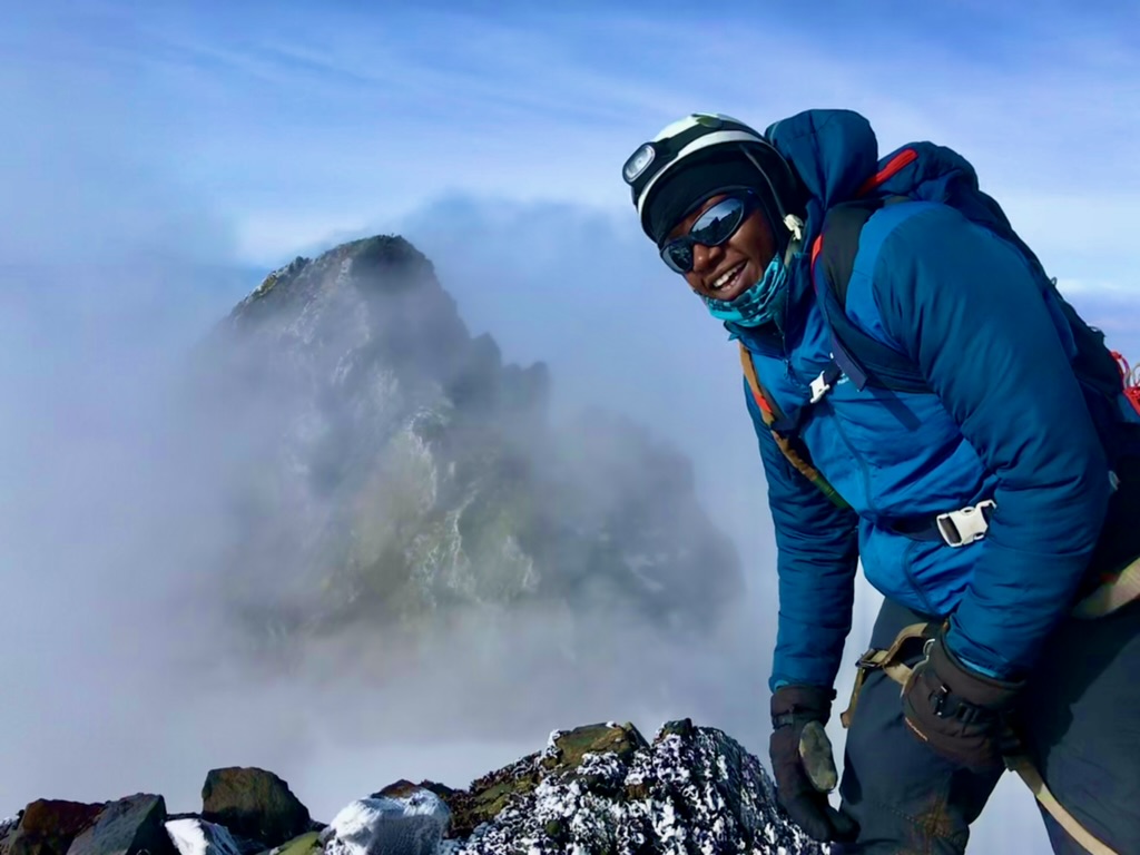
Day 7: Elena Hut – Margherita peak (5109m)
For those aiming at reaching Margherita peak (5109m), continue to the base of the Stanley Glacier. To reach the summit of Margherita, the climb takes about 5-7 hours depending on the weather conditions and the pace of climbing this mountain. This tough walk takes you over three glaciers, slippery rock, ice and very exposed areas which are open on many sides. Note that this climb is for only physically fit and technical climbers. Climbing on to the glaciers, cross the Stanley Plateau and proceed with the ascent. Acclimatized to fog, altitude sickness and coolly weather, scramble up to the summit of Margherita the highest peak of the Rwenzoris. Given the high altitude and the tough conditions even if you do not reach the peak, don’t get disappointed.
Reaching back to Elena hut, prepare for sloping down to Kitandara hut through Scott-Elliot pass, where there are spectacular views back to Bujuku Lake and Mount Speke, up to Mount Stanley and down to the Kitandara Lakes. After the trail that passes you through an alpine zone of sparse vegetation with beautiful gardens of flowering Asanasios, giant lobelias, and rough boulders, descend to the twins Lakes of Kitandara where you will enjoy the shores of Kitandara Lake which is worthy beach life and overnight at the Kitandara Hut. This also takes you to 2-3hours but ascending down throughout the hut. However, based on the time reached at Elena hut after margarita, you talk with your guide to have another night at Elena hut which will lead to an extra day.
Day 8: Kitandara Hut to Guy Yeoman Hut, 3.261 m.
From Kitandara, take on the trail that ascends steeply up the headwall, spreading out from the base of Mount Baker and continuing along the south side of the mountain to Fresh field Pass 4.282 m. At this point you can view into the Congo to the west and Mount Stanley to the north. From the pass, take on the long trail passing through bogy and slippery rocks that leads you to Bujongolo rock shelter the base camp for the historic expedition by the Duke of Abruzzi in 1906. The hut is surrounded by a beautiful landscape of mountains, vegetations dominated by the giant lobelias and rivers. Overnight at Guy yeoman and this takes 5-6 hours.
Day 9: Guy Yeoman Hut back to Nyabitaba Hut, 2652 m.
On this day you complete the central circuit by going back to Nyabitaba Hut. The trail is attractive along the valley of the Mubuku and Kichuchu rivers, rich in plants and flowers of the heather zone before reaching the bamboo forest. Time to reach Nyabitaba is about 4- 5 hours. Then to descend directly to Nyakalengija, adding 2-3 more hours where your transfer vehicle to Kasese town for an overnight stay will be waiting.
Day 10: Kasese – Kampala
In the morning, take breakfast and drive to Kampala either through Kasese-Fortportal road (372km) or Mbarara-Masaka road (422km) to reach Kampala /Entebbe for a flight/bus ride back home.
For more exciting climbs and related adventures in East Africa and beyond check out our adventure calendar here